The Root River State Trail is a 42-mile paved bike trail in southeast Minnesota that winds through the scenic Root River Valley with Lanesboro at its heart. Widely considered one of the most beautiful trails in Minnesota, it connects to the Harmony-Preston Valley State Trail, creating more than 60 miles of paved trail riding through Bluff Country.
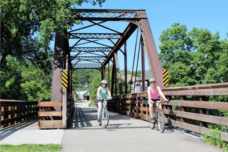
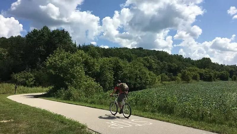
Widely considered one of the most popular paved bike trails in Minnesota, the trail winds through some of the region’s most striking landscapes. Cyclists travel beneath towering 300-foot limestone bluffs, past forested hillsides, river bottoms, and rolling farmland as the trail follows a former railroad corridor through the heart of Fillmore County.
Because the trail was built along a historic rail line, it maintains a gentle grade that makes it ideal for riders of all ages and skill levels, from casual family rides to long-distance cycling trips. Along the way, visitors often spot deer, wild turkeys, hawks, and bald eagles, highlighting the rich wildlife and rural character of Bluff Country.
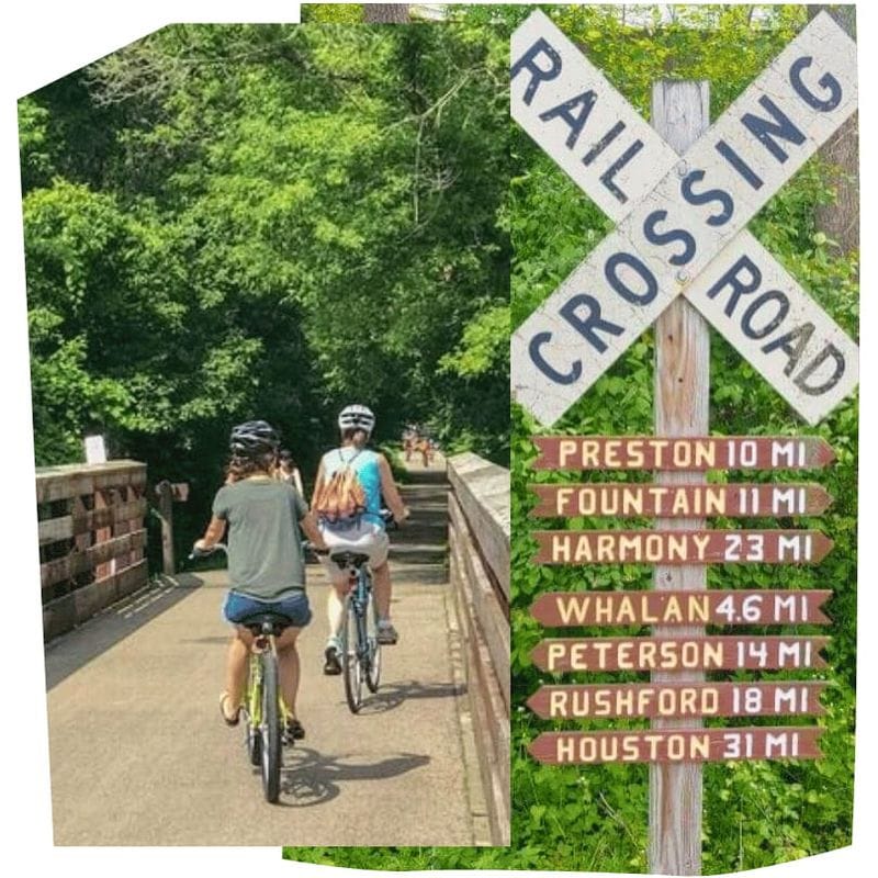
The trail connects a series of welcoming trail towns including Fountain, Lanesboro, Whalan, Peterson, Rushford, and Houston, where riders can easily access campgrounds, inns and B&Bs, restaurants, museums, bike outfitters, and locally owned shops.
Open year-round, the paved trail is popular for biking, walking, running, in-line skating, and cross-country skiing. In 2025, the Harmony-Preston Valley State Trail was extended south from Harmony to the Iowa border, further expanding the region’s growing network of connected Bluff Country cycling and recreation trails.
Length: 42 miles
Surface: Paved asphalt
Difficulty: Mostly flat rail-trail grade
Location: Southeast Minnesota (Bluff Country)
Trail Towns: Fountain • Lanesboro • Whalan • Peterson • Rushford • Houston
Connected Trail: Harmony-Preston Valley State Trail
Best Activities: Biking • Walking • Running • In-line skating • Cross-country skiing • Birding
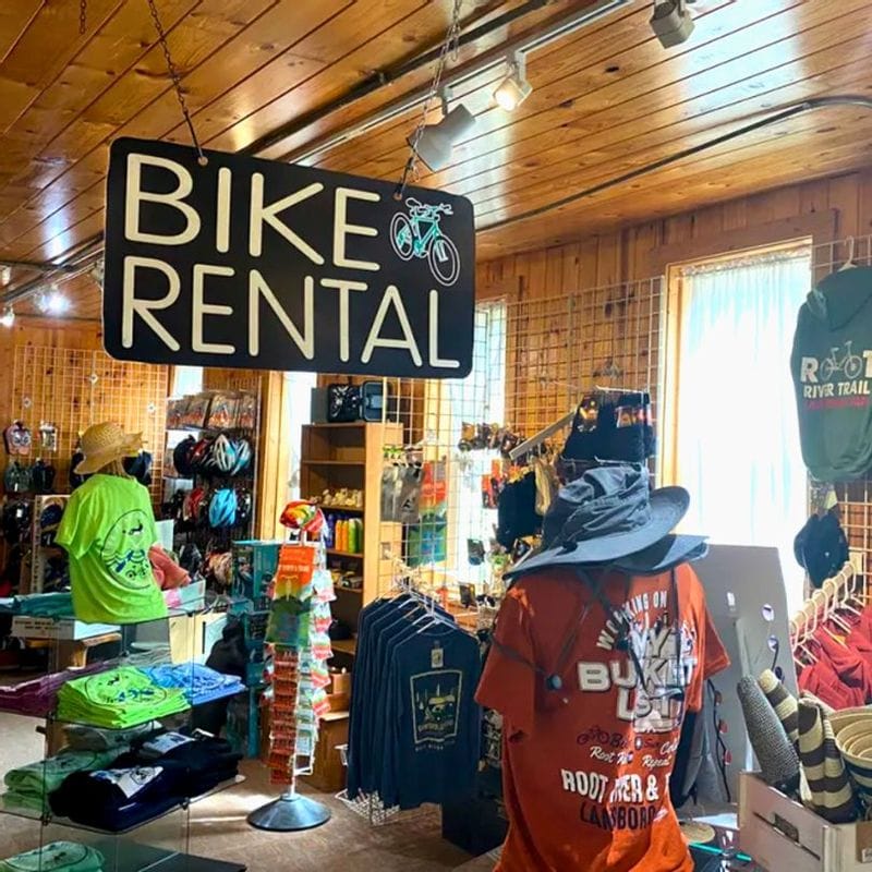
One of the best parts of experiencing the Root River State Trail from Lanesboro is how easy it is to get started. You don’t need to bring your own bike—local outfitters offer rentals just steps from the trail.
From downtown Lanesboro, you can rent a bike and ride directly onto the trail. The Visitor Center is the trailhead for Lanesboro, offering public restrooms, a water bottle filling station, and local guides and information.
Many visitors choose to ride from Lanesboro to nearby communities like Whalan or Preston, stopping along the way for food, drinks, and scenic views before returning to town. With mostly flat, paved miles following the river, the trail is an accessible and enjoyable ride for all ages and experience levels.
Whether you’re planning a full-day ride or a short outing, Lanesboro makes it simple to get on the trail and start exploring Bluff Country.
Now, getting to your favorite biking destinations in Fillmore or Houston County is easier than ever with Rolling Hills Transit! Their new buses are equipped with convenient bike racks, allowing you to seamlessly combine public transportation with your outdoor adventures.
The following trail information is from the Minnesota Department of Natural Resources Root River State Trail webpage.
Part of the Blufflands Trail System, the trail provides outstanding views of the soaring limestone bluffs of the Root River Valley. The trail rises and falls with the bluffs, winding through historic towns tucked into hillsides, past rolling farm fields, milling districts, and relics of the railroad's heyday. Lush and verdant stretches offer views of the area's natural beauty.
Wildlife is abundant, and sightings of wild turkey, deer, hawks and turkey vultures are common. Rattlesnakes can occasionally be found on rock outcrops, along the river bottoms, or sunning themselves on the trail. They are a state threatened and protected species, and should be left alone.
Historical buildings and rural communities along the trail provide sites of interest as well as many services. Campgrounds, bed-and-breakfasts, restaurants, museums, outfitters and unique stores can be found in many of the trail towns.
Restroom facilities are available along the trail at these points:
Cross-country skiing is popular on this trail in the winter. Most of the trail is groomed in the winter. There are 30 miles of set track from the Isinours Forest Recreation Area in Preston to the bridge outside of Houston. A Minnesota Ski Pass is required to ski on this trail. There is no snowmobiling on the trail, although the trail does briefly intersect with the Fillmore and Houston county Grants-in-Aid (GIA) trail system, which provides many miles of groomed snowmobile trails in the area.
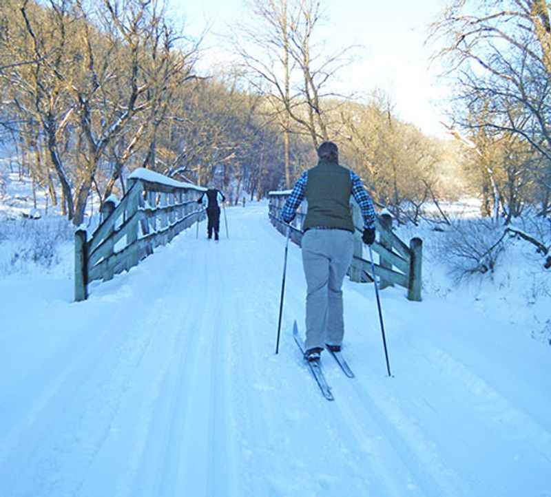
You will need a Ski Pass for cross-country skiing. No other fees or passes are required to use the trail.
Do not leave valuables in your vehicle!
Parking is available at the following trail accesses:
How long is the Root River State Trail?
The Root River State Trail is 42 miles long, running through southeast Minnesota’s scenic Bluff Country from Fountain to Houston as it follows the Root River Valley.
Is the Root River State Trail paved?
Yes. The entire Root River State Trail is paved with asphalt, making it one of Minnesota’s most accessible multi-use trails for biking, walking, running, and in-line skating.
Is the Root River State Trail flat?
Because the trail follows a former railroad corridor, it maintains a gentle grade with gradual elevation changes, making it ideal for riders of all ages and skill levels.
What towns are on the Root River State Trail?
The trail passes through several welcoming Bluff Country trail towns, including:
Each town offers places to stop for food, rest, lodging, and local attractions along the trail.
Where should you start the Root River State Trail?
Many visitors begin their ride in Lanesboro, which sits near the center of the trail and offers convenient access to bike rentals, lodging, restaurants, and trail services.
Do you need a pass to use the Root River State Trail?
Biking, walking, running, and in-line skating on the Root River State Trail do not require a trail pass. The trail is free to use for these activities during the warmer months.
In winter, however, cross-country skiers must have a Minnesota Ski Pass to use groomed state trails. Ski passes help support trail grooming and winter maintenance.
What is the most scenic section of the Root River State Trail?
Popular scenic sections include:
Many riders consider the Lanesboro area the heart of the trail, with some of the most striking Bluff Country scenery.
Does the Root River State Trail connect to other trails?
Yes. Just west of Old Barn Resort, the trail connects to the Harmony-Preston Valley State Trail, which extends south to the Iowa border, expanding the region’s growing network of connected Bluff Country cycling routes. There is also a trail spur that connects to Niagara Cave outside of Harmony.
Is the Root River State Trail good for families and beginner riders?
Yes. Because the Root River State Trail follows a former railroad corridor with gentle grades, it is widely considered one of the most beginner-friendly bike trails in Minnesota. The paved surface and gradual elevation changes make it ideal for families, casual riders, and multi-generation biking trips.
When is the best time of year to ride the Root River State Trail?
The trail is most popular from late spring through fall, when Bluff Country’s scenery is at its best. Summer offers warm weather and lively trail towns, while autumn is especially beautiful as the limestone bluffs and river valley fill with fall colors. The trail is also used in winter for cross-country skiing when conditions allow.
Where can you rent bikes for the Root River State Trail?
Bike rentals, e-bikes, and shuttle services for the Root River State Trail are available in Lanesboro, which sits near the center of the trail and serves as a popular starting point for riders exploring Bluff Country.
Are e-bikes allowed on the Root River State Trail?
Yes. Electric-assist bicycles (e-bikes) are allowed on Minnesota state trails, including the Root River State Trail, provided they follow state regulations. Riders should always operate e-bikes safely and adhere to all trail rules.
